
Most people who have been to Khunjerab Pass will tell you two things about it.
The first is that the drive up the Karakoram Highway is more impressive than the pass itself. The second is that they are glad they went anyway.
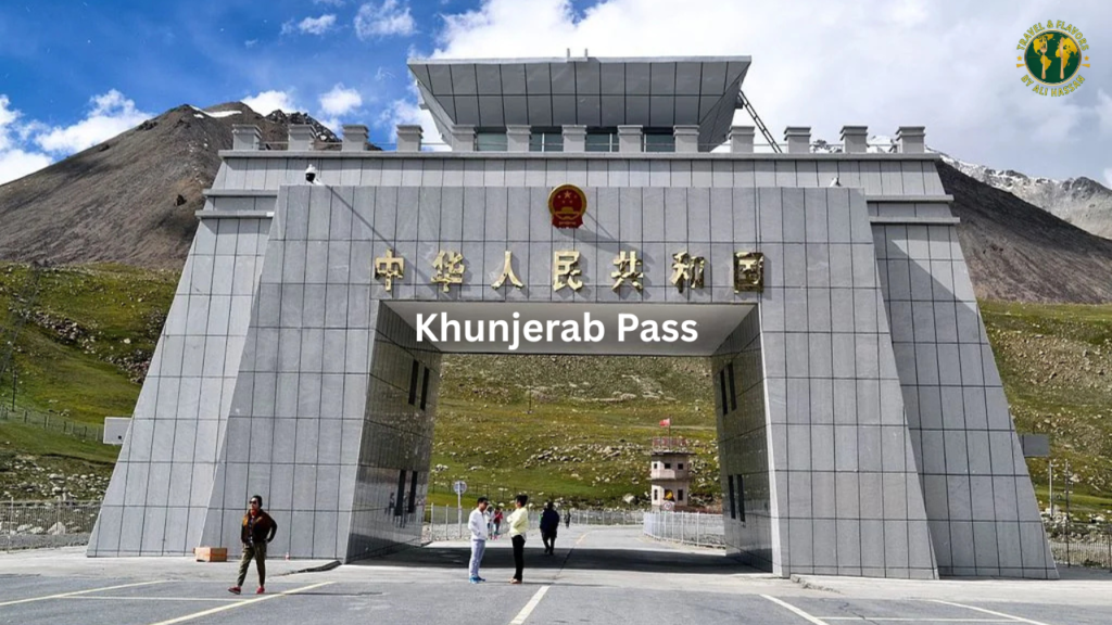
Both of these things are true at the same time, and understanding why requires separating what Khunjerab Pass actually is from what the photographs make it look like. The iconic image of a monumental gate at the Pakistan-China border, with snow peaks on both sides and a vast grassy saddle stretching toward the horizon, is accurate. What the photograph does not convey is the altitude. At 4,693 metres above sea level, Khunjerab Pass is the highest paved international border crossing in the world. You feel that height. Most visitors feel it within 20 minutes of arriving — a shortness of breath, a slight pressure behind the eyes, the odd sensation of your body working harder than usual just to stand still.
The name itself tells you something about the history of this place. Khunjerab comes from the Wakhi language and translates as “Valley of Blood.” The name is a reference to the historical raiding and violence that plagued this remote mountain corridor long before it became the well-paved border crossing it is today. Ancient traders on the Silk Road knew this passage well and knew its dangers equally well. The modern version, with its immigration posts and tourist buses and the single ATM that mostly does not work, is a considerably more peaceful version of the same geography.
This guide covers everything that actually matters before visiting Khunjerab Pass in 2026 — the access, the altitude reality, the fees, the wildlife, the honest assessment of whether it is worth the full day it takes to do it properly, and every practical detail that most travel blogs skip.
What Khunjerab Pass Actually Is
Khunjerab Pass sits at the northern end of the Karakoram Highway in Gilgit-Baltistan, forming the international border between Pakistan and China’s Xinjiang Uyghur Autonomous Region. The pass marks the highest point on the KKH and the endpoint of Pakistan’s road network in the north.
The border gate at the pass is Zero Point — the physical marker between Pakistan and China. Pakistani visitors can drive up to and photograph the gate without any special permit beyond their CNIC. Foreign visitors need their passport. Nobody crosses the actual border at Zero Point for tourism purposes — the immigration formalities for crossing into China happen at Sost on the Pakistan side (85 kilometres from the gate) and at Tashkurgan on the China side (about 100 kilometres from the gate). The gate itself is a photo opportunity and a geographic marker, not a functional checkpoint.
Khunjerab Pass is located within Khunjerab National Park, established in 1975, which covers 2,269 square kilometres of high-altitude terrain and is the highest national park in Pakistan. The park protects some of the most significant wildlife habitat in the Karakoram, including the primary ranges of the Marco Polo sheep, snow leopard, Himalayan ibex, and golden marmot. This wildlife dimension of the visit is something most tourists underweight when planning and then find themselves genuinely excited about when they see ibex on the roadside crags.
The road from Islamabad opened for tourist traffic in 1986, and the full KKH was completed in phases from 1979 onward. What was previously one of the most remote and inaccessible border zones on Earth became, over a few decades, a paved road that private cars and tourist vehicles can drive in summer without any technical equipment.
The Honest Assessment: Is Khunjerab Pass Worth It?
This question comes up constantly in Khunjerab Pass discussions and deserves a direct answer rather than the standard promotional deflection.
One prominent GB travel site states plainly that Khunjerab Pass is “overrated” if you visit it blind, that two hours at the top is more than enough, and that it may not be worth a seven-hour drive for everyone. This is an honest assessment that most official tourism content will not give you.
Here is the fuller picture: the pass itself is a geographic milestone and a compelling one, but the journey up the KKH is the main event. Attabad Lake, the Passu Cones, the Gulmit stretch, the wildlife through Khunjerab National Park, the dramatic narrowing of the valley as you climb toward the Chinese border — these are what most returning visitors describe as the most memorable parts of the day. The border gate is the destination, but the road is the experience.
If you are expecting a dramatic alpine viewpoint with panoramic mountain scenery in every direction, Khunjerab Pass delivers that. If you are expecting a bustling border town with food, shopping, and extended activities, you will find an immigration post, a few tourist stalls, thin air, cold wind, and that ATM that mostly does not work. Visitors consistently say they are glad they went. They also consistently say that 20 to 45 minutes at the top is enough before the altitude and the cold make a return to lower elevation welcome.
The verdict: go for the drive and the wildlife, treat the border gate as the satisfying punctuation at the end of a long sentence, and do not expect the destination to match the journey in terms of spectacle.
Getting There in 2026
From Islamabad
The full road distance from Islamabad to Khunjerab Pass is approximately 770 kilometres and takes roughly 10 to 12 hours of driving without overnight stops — which is not how anyone actually does this trip. The standard approach from Islamabad takes two to three days minimum, with overnight stops in Gilgit or Karimabad in Hunza before making the day trip up to the pass.
The KKH from Islamabad runs through Abbottabad, Mansehra, Besham, and Chilas before reaching Gilgit. The Kohistan section of this road requires daytime driving — the standard local advice is to depart Islamabad by 4 to 5am, because the stretch through Kohistan has significant drops, limited lighting, and rockfall risk in darkness. This applies year-round and is not optional caution.
An alternative route via Naran, Kaghan Valley, and Babusar Pass is more scenic but adds the Babusar Pass constraint: the pass sits at 4,173 metres and is typically closed from November through May, and even in summer is weather-dependent.
The fastest access is flying from Islamabad to Gilgit, a one-hour flight, followed by a 4 to 5 hour drive up the KKH to the pass. Gilgit flights are highly subject to weather cancellations — this is standard for all mountain airport routes in Pakistan and requires building schedule flexibility into any plan that relies on flying.
From Hunza / Karimabad
Most visitors who make it to Khunjerab Pass do so as a day trip from Karimabad in Hunza, which is the most common base for this excursion. The distance from Karimabad to the pass is approximately 170 to 175 kilometres and takes 4 to 5 hours each way with stops. A full day trip from Karimabad covers about 10 to 12 hours including driving time, stops at Attabad Lake, Passu, and wildlife zones, and 30 to 60 minutes at the pass itself.
Leave Karimabad by 7am at the latest. Afternoon weather at the pass deteriorates frequently, and arriving at high altitude in worsening weather with a long drive back is not a situation you want. Morning light is also significantly better for photography of the pass and the surrounding peaks.
The Road to Sost: What You Pass Through
The drive from Karimabad to Sost, the last Pakistani town before the pass, passes through several stops that are worth building proper time into.
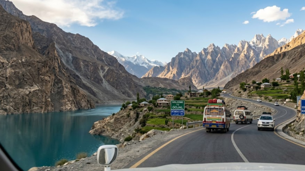
Attabad Lake was created in 2010 when a massive landslide blocked the Hunza River, creating a lake that submerged several villages and a 20-kilometre section of the original KKH. The water is a remarkable turquoise and the KKH now runs through tunnels carved into the cliff walls above the lake. The drive through these tunnels is dramatic, and the view of the lake from overlooks along the road has become one of the signature images of the KKH.
Gulmit and Passu come next as you enter Gojal, Upper Hunza. The Passu Cones, a series of jagged rock spires rising sharply from the valley floor, are among the most distinctive rock formations on the KKH and make a compelling photography stop. The famous Passu suspension bridge, a narrow rope bridge across the Hunza River, is a short walk from the road and a popular stopping point for those with a tolerance for bouncy crossings at height.
Sost is the last town of significance before the pass, with food, basic accommodation, and the Pakistani immigration post where passports are checked even if you are only visiting the pass and not crossing into China. The town has a dry port that serves CPEC trade traffic. There are restaurants and small shops at Sost, and this is the last chance for a proper meal before the altitude zone.
Fees, Documents, and Permits
For Pakistani nationals: Your CNIC is the only document required to visit Khunjerab Pass up to Zero Point. The Khunjerab National Park entry fee is Rs. 300 for Pakistani nationals.
For foreign visitors: Your passport is required. The national park entry fee for foreigners is Rs. 5,000. No special permit is needed to visit the Pakistan side of Khunjerab Pass up to the Zero Point border marker. Foreign visitors do not need a Chinese visa to visit the Pakistan side of the gate.
For those actually crossing into China: A valid Chinese visa is required and must be arranged in advance. Getting a Chinese visa has become more complex in recent years. In 2026, the standard advice is to arrange the visa before your Pakistan trip rather than attempting it in Islamabad, where approval is no longer reliably available for all nationalities. The border crossing into China is served by NATCO and Hunza-Xinjiang Trading Company buses. The Pakistan side operating hours are 9am to 5pm and the border is closed on weekends and public holidays. Those crossing in their own vehicles must travel in convoy with the official buses.
Photography near the border gate: Photography is permitted at the civilian border gate area. Restrictions apply near military installations. Follow any instructions from border officials without debate.
Cash: The single ATM at Khunjerab Pass, installed by a Pakistani commercial bank, is frequently offline. Do not rely on it. Carry cash for the national park fee, any food purchases at Sost, and any porter or service costs along the way.
Altitude: The Reality That Trips Most Visitors
At 4,693 metres, Khunjerab Pass sits at an altitude where most visitors feel something. The typical day trip from Karimabad takes you from approximately 2,400 metres to 4,693 metres in a single day, a gain of over 2,200 metres. This rate of ascent, while not unusual for a road trip, is fast enough that altitude-related symptoms are common even in healthy travelers.
The most frequent symptoms at the pass are shortness of breath, mild headache, fatigue, and a general sense of the body working harder than usual. For most day-trippers who descend after 30 to 60 minutes at the top and return to Karimabad’s elevation the same day, these symptoms are manageable and temporary. They are not a reason to avoid the trip.
The standard preparation advice: spend at least one or two nights at Hunza’s elevation of around 2,400 metres before attempting the pass. Going directly from Islamabad to Khunjerab Pass in a single push without acclimatization time is how people end up with severe altitude sickness. If you have been in Karimabad for a day or two, your body has begun adjusting and the altitude at the pass will be noticeably more manageable.
Drink water consistently throughout the day. Avoid alcohol for 24 hours before the visit. Walk slowly at the top — there is no race and the altitude makes any exertion feel disproportionately demanding. If headache worsens significantly, nausea becomes severe, or you experience confusion or loss of balance, begin descending immediately. These are symptoms of acute mountain sickness that require a lower elevation, not a wait-and-see response.
Wildlife: The Part Most Visitors Are Pleasantly Surprised By
Khunjerab National Park is not a side note to the pass visit. For many travelers, the wildlife along the road through the park is among the most memorable parts of the entire north Pakistan trip.
Himalayan ibex are the most commonly seen large mammal on the drive. They are frequently spotted on the rocky crags along the road, sometimes remarkably close to passing vehicles. The ibex population in this area has been protected long enough that the animals are habituated to vehicle traffic and do not immediately flee. A slow drive through the national park section with attention on the cliff faces produces ibex sightings on most visits.
Marco Polo sheep are rarer but present. They are distinguished from ibex by their enormous curved horns and tend to be spotted on the more open upper slopes. The Marco Polo sheep is classified as vulnerable and Khunjerab is one of the few places in Pakistan where wild populations remain.
Golden marmots are the most reliably entertaining wildlife encounter on the drive. They are visible from the road throughout the national park section, often sitting upright at the entrances to their burrows and producing a distinctive whistling alarm call when vehicles pass. Most visitors stop for photographs.
Yaks graze the high pastures near the top and are visible near the border gate area. These are typically domesticated yaks belonging to local Wakhi herding families, but the sight of them in the landscape makes the border gate area feel genuinely Central Asian in character.
Snow leopards are theoretically present within the park. Sightings from the road are extremely rare and should be treated as a pleasant surprise if it happens rather than a reasonable expectation. The park is core snow leopard habitat and the population is present, but the animal’s elusive nature means casual visitors almost never see one.
Drive slowly through the national park section. Your driver will usually know the spots where ibex are most frequently seen. Turn off the engine briefly if you want to hear the marmot calls without road noise.
The Road Itself: What the KKH Feels Like in 2026
The Karakoram Highway between Karimabad and Khunjerab Pass is in significantly better condition in 2026 than it was a decade ago. CPEC investment has improved road surfaces, widened sections, and added infrastructure on parts of the route. The section through Attabad Lake tunnels is particularly well-maintained.
That said, this is still a high-mountain highway in an active geological zone. Landslides close sections of the KKH multiple times each season. The 2026 season opened with the road fully cleared as of June 1st, but the window between that clearance and the arrival of any given traveler can include new landslide events. Checking current road conditions before departure — from your hotel in Karimabad, from local drivers, or from the Gilgit-Baltistan Tourism Department{target=”_blank” rel=”noopener noreferrer”} — is genuinely necessary rather than just standard caution.
The stretch between Sost and Khunjerab Pass is where the road becomes most demanding. The elevation gain over a relatively short distance is significant, the road narrows, and the views become increasingly dramatic. This section requires confident driving and good vehicle maintenance. Rental vehicles from Karimabad or Gilgit whose drivers know the road are the right choice for visitors who have not driven high-altitude mountain roads before.
Practical Details for 2026
Season: Khunjerab Pass is open to tourists from approximately April to November. The road was fully cleared as of June 1, 2026. Peak access is June through September. October remains accessible but with increasing cold and early snow risk at the top. November and December close the road progressively.
Best time to leave: Depart from Karimabad no later than 7am. This gives you full morning light for the drive, time for stops at Attabad and Passu, and ensures you reach the pass before early afternoon weather changes.
What to wear: Even in July, Khunjerab Pass is cold. Temperatures at 4,693 metres in summer are typically 5 to 15 degrees Celsius in the day, dropping quickly with cloud cover or wind. A proper jacket, layers, and warm gloves are non-optional regardless of how warm the Karimabad morning was when you left.
Food: The only reliable food available between Sost and the pass is whatever you bring. Sost has restaurants and small shops for a proper meal before the climb. A thermos of chai, snacks, and extra water carried from Sost will serve you well for the hours between Sost and your return.
SCOM SIM: Mobile coverage from major Pakistani carriers drops significantly past Karimabad and is unreliable through much of Gojal and the national park area. SCOM is the most functional carrier in this region. Purchase a SCOM SIM in Gilgit if you want any mobile connectivity on this stretch.
Passport / CNIC: You will be asked for documents at the Sost checkpoint even if you are only going up to the pass as a tourist and not crossing into China. Having your documents immediately accessible rather than buried in your bag saves time at the checkpoint.
How Khunjerab Pass Fits Into the North Pakistan Circuit
Khunjerab Pass makes most sense as the northernmost point of a Hunza-based itinerary. It is rarely worth making a standalone trip to the pass without spending proper time in the Hunza Valley.
The Hunza apricot season shapes the broader Hunza experience in a way that directly affects what you see on the way up to Khunjerab. During blossom season in March and April, the orchards of Karimabad and Altit are flowering. By the time the pass opens fully in June, harvest season approaches. Our guide on Hunza apricot season explains both windows in detail and is worth reading alongside your Khunjerab Pass planning.
Fairy Meadows Pakistan is the other major destination that most KKH travelers combine with a Khunjerab trip on the same northern circuit. Our guide to Fairy Meadows Pakistan covers the jeep track reality, accommodation truth, and the altitude preparation that applies equally to Khunjerab Pass planning.
Many north Pakistan travelers approach from the west via Chitral and the Shandur Pass route rather than directly up the KKH. Our guide on things to do in Chitral covers that western approach including the cultural contrast between Chitral’s Hindu Kush environment and Hunza’s Karakoram character.
If Skardu is part of the itinerary alongside Hunza and Khunjerab, the seasonal planning matters specifically because Deosai National Park access, the most consequential Skardu attraction, has a shorter window than Khunjerab itself. Our Skardu in summer vs winter comparison covers that trade-off in detail.
Islamabad is where almost every north Pakistan trip begins and ends, and our guide on things to do in Islamabad covers the capital as a proper destination rather than just a transit stop.
The M2 motorway is the first major road of every northern Pakistan journey originating in Lahore. Our guide to the best dhabas on the Lahore Islamabad motorway covers food stops on that section that make the long drive north considerably more comfortable.
For the broader winter perspective on what this entire mountain region looks like outside the summer tourist window, our piece on winter travel in Northern Pakistan gives context on how the food, travel conditions, and atmosphere differ from the summer Khunjerab experience.
Frequently Asked Questions: Khunjerab Pass
Yes. The road was fully cleared as of June 1, 2026 and the pass is open for tourists. Khunjerab Pass typically opens in April or May depending on snow conditions and closes with heavy snowfall in November. Always verify current road conditions with local sources before departure.
Pakistani nationals need only their CNIC. Foreign visitors need their passport. No special permit is needed to visit the Pakistan side up to Zero Point. A valid Chinese visa is required for anyone actually crossing into China. The Khunjerab National Park entry fee is Rs. 300 for Pakistanis and Rs. 5,000 for foreigners.
From Karimabad in Hunza, the drive takes approximately 4 to 5 hours each way including the Sost passport check and stops along the road. A full day trip from Karimabad is a 10 to 12 hour day with driving, stops, and time at the top.
Khunjerab Pass sits at 4,693 metres (15,397 feet) above sea level. It is the highest paved international border crossing in the world. Most visitors experience some degree of altitude-related symptoms including shortness of breath and mild headache. Spending one to two nights at Hunza’s elevation before the visit significantly reduces altitude sickness risk.
The most reliably spotted animals are Himalayan ibex (frequently seen on roadside crags), golden marmots (visible throughout the national park section), and grazing yaks near the border gate. Marco Polo sheep are present but less commonly seen. Snow leopards inhabit the park but sightings from the road are extremely rare.
Yes, but only with a valid Chinese visa arranged in advance. The crossing is served by NATCO and Hunza-Xinjiang Trading Company buses. The border is open Monday through Friday, 9am to 5pm Pakistan time, and is closed on weekends and public holidays. Chinese immigration formalities are processed at Tashkurgan, approximately 100 kilometres from the gate on the Chinese side.
There is one ATM at the pass installed by a Pakistani commercial bank. Multiple visitor reports confirm it is frequently offline or out of service. Carry sufficient cash from Karimabad or Sost and do not rely on the ATM.
Warm layers including a jacket for the cold at altitude even in summer, your CNIC or passport, cash for the national park fee and any purchases in Sost, water and snacks for the section between Sost and the pass, and a SCOM SIM if you want mobile connectivity in the Gojal and national park area.
Khunjerab Pass visits generate strong opinions, particularly around the question of whether the destination justifies the journey. If your experience confirmed or contradicted what is in this guide, or if road or permit conditions have changed since this was written, the comments section is the right place for that information. Current-year traveler experience is always more useful than any guide written before your trip.