
There is a sentence that appears in almost every conversation about Kumrat Valley among people who have been there: “I can’t believe I hadn’t heard of this place before.”
It makes sense when you look at the numbers. Most Pakistani travelers who grew up reading about northern destinations learned about Swat, Naran, Hunza, and Skardu. Kumrat was always there, tucked into the Upper Dir district of Khyber Pakhtunkhwa, running 35 kilometres along the Panjkora River through deodar cedar forests that are among the densest and tallest in the country. But the road stopped most people. For a long time, getting to Kumrat Valley meant navigating a jeep track that sorted out the serious visitors from the casual ones before you ever reached the valley floor.
That dynamic has changed somewhat. Better road infrastructure, the viral spread of Kumrat photography across Pakistani social media, and the general growth of domestic tourism in KPK have all brought more visitors to the valley. During Eid holidays in 2025, operators recorded approximately 2,000 vehicles entering the valley daily. By Pakistani mountain standards, that is significant. By international alpine standards, Kumrat remains remarkably unaffected, still genuinely wild, still genuinely quiet on a mid-week morning in June when the Eid crowds have gone home and the deodar forest is doing what it has always done.
This guide covers everything that actually matters for planning a Kumrat Valley trip in 2026, from the road reality to the specific trekking options, from honest accommodation assessments to the cultural context that makes the visit more than just another mountain destination.
Where Kumrat Valley Is and Why It Matters Geographically
Kumrat Valley sits in the Upper Dir district of Khyber Pakhtunkhwa, part of the region historically known as Dir Kohistan, running roughly 35 kilometres along the Panjkora River. The valley’s GPS coordinates place it at approximately 35°32’N, 72°13’E, which positions it in the southern Hindu Kush range, west of Swat and north of Dir city. It is close to the Afghan border in the way that much of Upper KPK is close to the Afghan border, without this being a practical concern for tourists.
The elevation at the main camping and accommodation area is approximately 2,400 metres, rising to 3,100 metres and beyond at the upper meadows and trek destinations. This elevation produces a specific climate: proper mountain cool even in summer, temperatures ranging from 6 to 16 degrees Celsius during the day in July and August, with cold nights requiring layers regardless of how warm the afternoon feels.
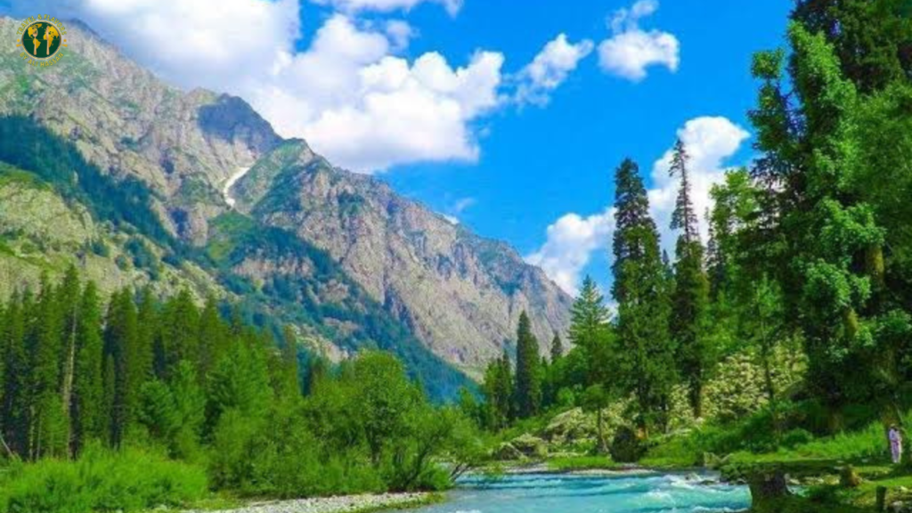
What sets Kumrat apart from its more famous neighbours is the forest. The deodar cedar forests of Kumrat Valley are among the densest concentrations of this tree in Pakistan. Deodar, the national tree of Pakistan, produces some of the largest specimens in the world here, with trees several centuries old and heights exceeding 40 metres. Walking through the valley’s core forest sections is not a minor attraction on the way to something else. It is a destination experience in itself, the kind of forest that genuinely makes noise when wind moves through it, that has a cathedral quality in the morning light that no photograph captures adequately.
The Panjkora River runs through the centre of the valley, fed by glacial melt from the Hindu Kush peaks above. The river is the visual and auditory spine of Kumrat. Every campsite in the valley main area is within earshot of it, and its sound at night, amplified in the relative silence of a valley with no industry and no traffic after 9pm, is one of the more memorable aspects of staying here.
Getting to Kumrat Valley in 2026: The Honest Route Guide
From Islamabad: The Standard Route
The most common approach is from Islamabad via the Swat Motorway, and it goes like this:
Take the M-1 Motorway toward Peshawar, then the Swat Motorway (M-16) from Chakdara. Continue on the N-45 highway through Timergara, the commercial hub of Dir district, then north through Dir city to the town of Thal. This section from Islamabad to Thal covers approximately 370 to 385 kilometres and takes 8 to 10 hours of driving depending on traffic through the urban sections.
Thal is the last town accessible by regular two-wheel-drive vehicles. Park here, eat a proper meal, fill your water, and arrange your jeep.
The final 20 to 30 kilometres from Thal to the main Kumrat Valley camping and accommodation area is where the road becomes a jeep track. Stream crossings, rocky surfaces, steep inclines, and sections where the track narrows to single-vehicle width are the norm rather than the exception. This section takes between 45 minutes and 3 hours depending on road conditions, the specific vehicle, and the driver’s knowledge of the route. In wet weather after rain, the stream crossings become significantly more challenging and some become impassable for several hours.
Most visitors who drove to Kumrat Valley in a regular car and attempted the jeep track section describe the attempt as something they would not repeat. Several have noted scratched undersides, stuck vehicles, and at least one memorable incident involving a door mirror and a rock face. The jeep track requires ground clearance and 4×4 traction. Standard sedans and even most modern SUVs with low ground clearance are not appropriate for this section.
The Alternative: Kalam to Kumrat via Badgoi Pass
For those approaching from Swat, a higher-altitude route connects Kalam through Badgoi Pass (approximately 3,500 metres) into Kumrat from the eastern side. This route is only open in summer, roughly June through September, and requires a 4×4 vehicle and ideally a guide who knows the pass. It is longer than the Thal route, more demanding, less travelled, and rewards those willing to commit to it with a completely different visual experience — the descent into Kumrat from the Swat side gives you the valley from above before you descend into it, which produces an arrival moment that no one who has done it forgets.
The Badgoi Pass route is mentioned in most Kumrat guides as a footnote. It deserves more prominence for travellers who are already in Swat and want to approach Kumrat without backtracking through Dir. The trade-offs are real — the route is harder, longer, and requires more vehicle and driver preparation — but for the right traveller it is the better approach.
From Lahore: The Long Haul
From Lahore, Kumrat Valley is approximately 690 to 730 kilometres away and 12 to 14 hours of driving. The route goes via the Lahore Islamabad motorway and continues north as above from Islamabad. Most Lahore-based visitors split the journey over two days with an overnight in Islamabad or on the road near Swabi.
Peshawar is the closest major city to Kumrat Valley at approximately 330 to 380 kilometres and is often the most convenient jumping-off point for KPK residents.
The Jeep Situation: What It Costs and How to Handle It
At Thal, the local jeep drivers operate through an informal union structure similar to what you find at mountain destinations across northern Pakistan. The rates in 2026 are approximately:
Rs. 8,000 to 9,000 for a basic return jeep from Thal to the main valley area. Rs. 14,000 to 20,000 for extended trips including Jahaz Banda and Katora Lake, depending on the vehicle type and duration. A Prado or Land Cruiser will cost more than a standard Hilux. Rates go up during peak season (June through August) and are more negotiable in the shoulder months.
The critical practical point: write down your driver’s name and number. Jeep drivers at mountain destinations across Pakistan, whether at Fairy Meadows or Kumrat, sometimes become unavailable if you do not keep track of who you hired. Having their contact information means you are not stranded when it is time to return to Thal.
Share the jeep cost with other travelers at Thal if you are travelling independently. The valley attracts enough visitors during summer that finding others heading the same direction at Thal on any given morning is not difficult. Sharing between four people at Rs. 8,000 round-trip means Rs. 2,000 per person, which is a very different budget impact than paying alone.
Jeep drivers at Thal also function as informal guides and know the valley well. If you want to see specific spots or ask about current conditions on the Jahaz Banda track, your driver is a reliable source of information. Build a working relationship with them during the drive rather than treating the jeep as a taxi.
What to Actually Do in Kumrat Valley
The Main Valley: Panjkora Riverbank and Deodar Forest
The most underestimated activity at Kumrat Valley is simply being in it. Most first-time visitors arrive focused on getting to Jahaz Banda and Katora Lake, which are the famous attractions. These are worth doing. But the valley floor itself, the riverbank, the deodar forest, the meadow areas near the camping grounds — these are where you understand why people come back to Kumrat.
The Panjkora River is at its most powerful in June and July when glacial melt is at its peak. The water runs turquoise-green and cold enough to be genuinely numbing if you wade in, which most visitors do at some point. The riverbank between the camping area and the upper forest is where Kumrat’s most atmospheric moments happen: the dappled light through deodar trees in the morning, the sound of the current at night, the specific silence of a forest valley where the only sounds are water, wind, and the occasional bird.
The Kumrat Waterfall, within walking distance of the main camping area, is the first significant attraction for most visitors. It drops from rocky cliffs into a pool surrounded by pine forest. The fall is at its most powerful in early summer when snowmelt is maximal and begins to reduce in August as the glacial contribution decreases. A photography spot, a swimming spot for the brave, and a picnic area for everyone else.
Kala Chashma, the Black Spring, is a natural cold water spring within the valley known for water so cold and clear that visitors consistently describe it in slightly disbelieving terms. It is a short walk from the main camping area and makes a natural stop before or after the waterfall.
Jahaz Banda: The Trek That Defines Kumrat
Jahaz Banda is a high-altitude alpine meadow at approximately 3,400 metres above sea level, reached by a combination of jeep track from the main valley (roughly 1 to 1.5 hours to the drop-off point) and a 2 to 3 hour trek upward through the forest and then onto open alpine terrain.
The name “Jahaz Banda” translates approximately as “airplane flat” in the local Gawri language, a reference to the meadow’s unusual flatness at high altitude. From certain angles in certain light, the plateau does look like a landing strip carved into the mountains. The reality on arrival is a broad alpine meadow surrounded by Hindu Kush peaks, with wildflowers in July, a cold stream running through the centre, and a view back down the valley that makes the climb feel entirely proportionate to the reward.
The trek to Jahaz Banda is achievable for reasonably fit hikers without technical experience. The elevation gain from the drop-off point to the meadow is significant enough that altitude effects are felt if you arrived at Thal from the plains that same day. Spending one night at the main valley before doing the Jahaz Banda trek gives your body meaningful adjustment time and noticeably improves the trekking experience.
There are basic camp arrangements at Jahaz Banda for those who want to sleep up here, and the night sky at 3,400 metres above the valley floor is worth the extra effort of camping rather than day-tripping back down.
Katora Lake: The Trek Beyond Jahaz Banda
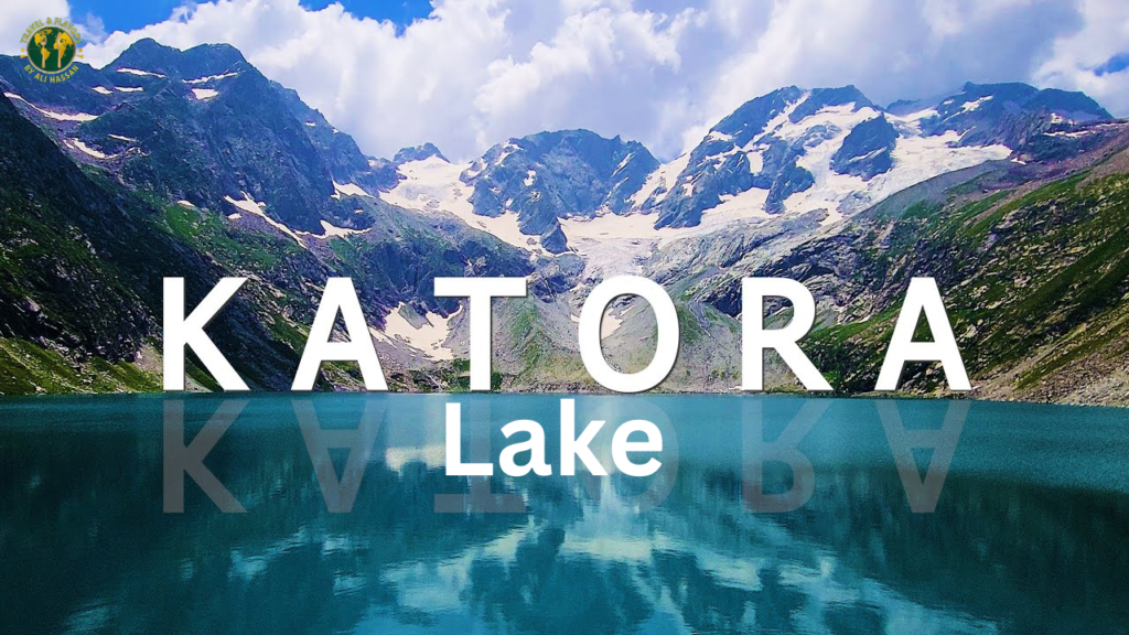
Katora Lake sits at approximately 4,000 metres above sea level, roughly 6 kilometres of trekking beyond Jahaz Banda. The name means “bowl” in the local language, and the lake’s shape is exactly that — a glacial bowl cupped beneath Spindhor Peak, filled with still water that reflects the rocky ridges and snow patches above it with a clarity that stops most people mid-stride when they first see it.
At 4,000 metres, Katora Lake is genuinely high-altitude trekking. The approach from Jahaz Banda takes 3 to 4 additional hours of uphill walking through increasingly rocky terrain. The air is thin enough at the lake that a short rest between steps becomes natural rather than embarrassing. Altitude sickness is a real consideration — anyone with a history of AMS, or who has not spent at least one night at the valley’s elevation before attempting this trek, should approach Katora Lake carefully and be prepared to turn back if symptoms develop.
The reward for those who reach it: the lake is the visual climax of the entire Kumrat Valley experience. The combination of the glacial water, the rocky cirque, the Hindu Kush peaks reflected in the still surface, and the knowledge that almost nobody knows this place exists compared to Hunza or Skardu — that combination produces the particular satisfaction of a destination that has not been oversold. Katora Lake looks exactly like the best version of what it is.
A small café operates at the lake during summer months, serving basic tea and snacks to trekkers who arrive at the top already slightly altitude-affected and in need of something warm. This detail, mentioned in multiple visitor accounts, has a disproportionately large role in how people feel about the experience.
Boat rides on Katora Lake cost approximately Rs. 1,000 per hour in 2026.
Dojanga and the Upper Meadows
Further up the valley beyond the main camping area, Dojanga and the upper meadow sections are quieter than both the main waterfall area and the Jahaz Banda trail. These are grazing areas where local Gawri herders bring their flocks in summer, and the landscape here is open in a way that contrasts with the dense forest below. For visitors who want to experience Kumrat without the relative bustle of the main camping area, spending a morning walking up to the upper meadows and sitting with the view is time well spent.
The Gawri People: The Cultural Context That Most Guides Skip
The indigenous inhabitants of Dir Kohistan are the Gawri, a Dardic people speaking the Gawri language (also called Kalkoti), which is related to other Dardic languages of the Hindu Kush but distinct enough to be unintelligible to Pashto or Urdu speakers without translation. The Gawri have lived in this valley system for centuries and maintain a cultural relationship with the deodar forests and the Panjkora River that predates any concept of tourism.
Visiting Kumrat Valley with awareness of who lives here changes the experience. The wooden houses in Thal and the valley settlements are traditional Gawri architecture, built with deodar timber and designed for the specific thermal requirements of a mountain winter that can drop to minus 10 degrees Celsius. The centuries-old wooden mosque at Thal, mentioned by multiple visitors as a genuinely striking piece of traditional architecture, is an active place of worship and a piece of cultural heritage that has no equivalent in better-known tourist destinations.
When visiting Kumrat: dress modestly, ask before photographing individuals, accept offers of tea when extended, and buy handicrafts directly from local artisans rather than from middlemen shops in Dir or elsewhere. These are not just courtesy guidelines. They reflect the terms on which Gawri communities have chosen to engage with tourism, and respecting them maintains the social conditions that make Kumrat the kind of destination it is rather than the kind of destination that gets loved to death.
One detail that surprises first-time visitors: there is a system called “ijara” in Kumrat Valley whereby campers who set up tents on valley land are expected to pay a small fee to the local landowners, even if they brought their own camping equipment. This is not a scam. It is a locally managed system that ensures the communities who maintain the valley receive direct economic benefit from the tourism it generates. The fee is modest and the logic is sound.
Accommodation in Kumrat Valley 2026
The accommodation situation at Kumrat Valley has improved significantly since the valley became a mainstream domestic tourism destination, but it still requires realistic expectations.
Riverside hotels and guesthouses at the main valley area range from basic rooms with shared facilities to mid-range guesthouses with private bathrooms and hot water. Panjkora Hotel is among the better-known options, with a riverside setting and reasonable facilities for a remote mountain destination. Prices in peak season run Rs. 2,000 to 5,000 per room depending on the facility level.
Camping remains the most popular accommodation format for independent travelers and friend groups. The camping grounds along the Panjkora River are well-established, with local camping operators providing tents, bedding, and basic meals at package rates. A camping package covering tent, meals, and basic firewood typically runs Rs. 1,500 to 3,000 per person per night in 2026.
Resort-style accommodation has begun to appear at Kumrat in the form of glamping setups and more organized family-friendly stays. Celine Resort is among the more frequently mentioned options by visitors who want something beyond basic camping without driving entirely upscale. The government-managed camping pods, bookable at KumratTourism.com, are another option for those who want the camping experience without bringing their own equipment and are willing to book well in advance.
The peak season reality: from late June through August, and especially during Eid holidays, accommodation at Kumrat books out well in advance. During Eid al-Fitr in 2025, the valley was recording 2,000 vehicle entries daily, and multiple visitors reported having to sleep in their vehicles for lack of available accommodation. Booking a minimum of 8 weeks ahead for Eid travel is essential. For non-Eid summer weekends, 2 to 3 weeks ahead is appropriate. Weekday visits in June or September are the lowest-risk approach for accommodation availability.
Food at Kumrat Valley
Food at Kumrat is campfire food, and this is a feature rather than a limitation.
The standard meal culture at the valley’s camping areas and small dhabas runs on barbecued meat over wood fire, fresh bread baked in clay ovens, daal and rice as the reliable staple, eggs and parathas for breakfast, and tea that runs continuously from the moment you wake up until the moment you sleep. None of this is sophisticated. All of it is appropriate for the setting.
The best food experiences at Kumrat Valley happen when you arrange meals with local guesthouses or camping operators rather than relying on improvised cooking. The local food in Thal and the valley covers the basics excellently. Bring snacks, chocolates, and anything you specifically need for energy on the Jahaz Banda trek — by the time you are at 3,400 metres, the ability to eat something familiar and calorie-dense matters more than food quality.
For serious food travelers, Kumrat Valley is an interesting data point in the broader story of what Pakistani mountain food tastes like at altitude. Our piece on Pakistan’s hidden food gems gives that context — the daal and bread culture of KPK’s mountain valleys is a direct cousin of the food traditions documented there.
If you are coming from Lahore and curious about the food culture on the way north, the nihari culture of Lahore and the street food of Faisalabad represent the plains food baseline that the mountain food of Kumrat diverges from so completely.
Best Time to Visit Kumrat Valley
The accessible season for Kumrat Valley runs from May to October, with different windows optimized for different experiences.
May and early June offer the valley at its emptiest in terms of tourists, with snow patches still visible on the upper ridges and the Panjkora running at its fullest and most powerful from winter snowmelt. The deodar forest is intensely green. The weather is cool and unpredictable. This is the window for travelers who prioritize solitude over guaranteed sunshine.
June through August is peak season. The Jahaz Banda meadow reaches its wildflower maximum in July. Katora Lake is fully accessible from July onward as the approach trail clears of snow. Temperatures are pleasant. The camping culture is at its most active and social. The crowd levels are at their highest, particularly on weekends and Eid periods.
September is the shoulder season equivalent of what September is for Skardu and Hunza — arguably the best month to visit for travellers who can plan around it. The summer crowds thin significantly after schools reopen and the Eid periods are past. The weather stabilizes. The light changes to the richer autumn quality. Accommodation is more available. If your schedule is flexible, September is the honest recommendation.
October is possible but late. Weather becomes increasingly unpredictable, and snowfall events that close the jeep track before it reopens are not uncommon in the second half of October. Early October visitors have a reasonable window; late October is a gamble.
Winter (November to April) brings heavy snow to the upper valley and makes Kumrat generally inaccessible except for experienced mountaineers with proper equipment. Snowfall in the valley can reach 3 to 11 feet at peak winter depths. If winter mountain experiences interest you, our guide on winter travel in Northern Pakistan covers what the northern circuit looks like in its cold months more broadly.
How Kumrat Valley Fits Into a Larger Pakistan North Trip
Kumrat Valley occupies a specific geographic and cultural position in the northern Pakistan circuit that most travelers are building when they visit KPK and Gilgit-Baltistan.
It is a natural pair with Chitral — both are Upper KPK destinations in the Hindu Kush system, both require commitment to reach, and both reward visitors with genuinely distinctive cultures (the Kalash people in Chitral, the Gawri in Dir Kohistan). A traveller visiting one and curious about the other is doing exactly the right kind of northern Pakistan exploration.
Kumrat can also be incorporated into a broader KPK loop that includes Swat, Kalam, and then crosses via Badgoi Pass into Kumrat before returning south through Dir. This loop covers some of the most compelling mountain scenery in KPK without duplicating the routes that most group tours follow.
For travelers combining KPK with Gilgit-Baltistan, Skardu is the natural next northern chapter after Kumrat, reached by returning to Islamabad and going up the KKH. Fairy Meadows adds the Nanga Parbat base experience to that KKH leg. Hunza Valley and ultimately Khunjerab Pass form the complete northern arc.
Most of these trips begin in Islamabad, and the capital is worth spending real time in before or after the mountains.
For the 10 best countries to visit in winter, Kumrat Valley in its winter form would be an unusual but compelling entry — not because it is comfortable in winter, but because the snow-covered deodar forest and frozen upper reaches have a quality that very few people have ever seen or documented.
One external resource that deserves a direct link for practical 2026 planning: KPK Tourism’s official portal{target=”_blank” rel=”noopener noreferrer”} maintains updated road condition advisories and accommodation registration lists for the Upper Dir region. Official confirmation of jeep track conditions after rain or snowfall events is more reliable from this source than from any tour operator or social media post.
Practical Information 2026: The Things That Matter
Mobile connectivity: Signal is weak in the main valley and essentially nonexistent in the upper areas toward Jahaz Banda. Download offline maps (Google Maps or Maps.me) before leaving Thal. Tell someone your plans and expected return date before going into the upper valley without connectivity.
Cash: There are no ATMs in Kumrat Valley or at Thal. Carry sufficient cash from Dir or Timergara. Budget Rs. 15,000 to 25,000 per person for 3 to 5 days covering jeep hire, accommodation, food, and a buffer for unexpected costs.
What to pack: Warm layers for nights (temperatures drop to 5 to 10 degrees Celsius even in July), rain gear (afternoon showers are common in summer), good trekking footwear with ankle support for Jahaz Banda and Katora Lake, sunscreen for the UV at altitude, a headlamp for camp use, and a reusable water bottle since the Panjkora River and springs throughout the valley produce water that is clean enough to drink directly.
How many days: Three days is a minimum for a meaningful Kumrat Valley experience. One day in the main valley and waterfall area, one day for Jahaz Banda, one day for Katora Lake if fitness permits. Five days is better and allows a more relaxed pace that actually lets the valley settle into memory rather than rushing through it.
Safety: Kumrat Valley is considered safe for domestic and foreign tourists. The main risks are weather-related (afternoon storms on the Jahaz Banda and Katora Lake trails are common and require turning back if conditions deteriorate), river-related (never attempt to cross the Panjkora at high flow — wait), and altitude-related for the Katora Lake approach.
Frequently Asked Questions
They are genuinely different destinations. Swat has more developed infrastructure, easier access, and a broader range of historical and cultural sites. Kumrat has deeper forest, less commercialisation, wilder scenery, and a rawer mountain experience. Most travelers who have visited both say Kumrat is the better nature experience and Swat is the more complete tourism package.
Regular vehicles can reach Thal, which is roughly 20 to 30 kilometres from the main valley area. The section from Thal to Kumrat requires a 4×4 jeep. Jeep rentals at Thal are available at Rs. 8,000 to 20,000 depending on route and vehicle type. Attempting the Thal to Kumrat track in a regular vehicle is not recommended and frequently results in stuck or damaged vehicles.
Yes, during summer months with proper planning. The main valley area is family-friendly. The Jahaz Banda trek is suitable for older children and teenagers with reasonable fitness. Katora Lake is more demanding and requires honest assessment of fitness for children. Book accommodation in advance, particularly during Eid and peak summer.
A 3-day independent trip costs approximately Rs. 15,000 to 25,000 per person including transport from Islamabad, jeep hire, accommodation, and food. Package tours from Islamabad run Rs. 35,000 to 65,000 per person depending on duration and whether Jahaz Banda and Katora Lake are included. Katora Lake packages from Islamabad can reach Rs. 85,000 to 150,000 per person.
Eid holidays are the peak congestion period, with 2,000 vehicles per day recorded in 2025. July and August weekends are significantly busier than weekdays. May, early June, and September offer the best combination of good weather and manageable crowd levels.
The Gawri are the indigenous Dardic people of Dir Kohistan who have inhabited the Kumrat Valley region for centuries. Visiting with basic awareness of their culture, dressing modestly, asking before photographing individuals, and buying from local artisans rather than middlemen — these practices make the visit more respectful and more interesting than treating the valley purely as a landscape destination.
Kumrat Valley is one of those places that grows in your memory rather than fading from it. The more time you spend there, the more specific the recollections become: the exact light through deodar trees at 7am, the temperature of the Panjkora against your feet, the view from Jahaz Banda when the cloud breaks after a morning of grey. If you have been to Kumrat Valley and found something this guide missed, or if conditions have changed since this was written, the comments section exists for exactly that purpose. Recent visitor experience is always more useful than any guide written before your trip.